Temperature changes occurring without the addition or subtraction of heat are called Adiabatic temperature changes.
This is different from latent heat which changes state of a substance without altering temperature.
Like pumping a bicycle tire, air in the pump is compressed and heated when the barrel is pushed downwards. Conversely, it cools upon lifting the barrel.
Similarly, as air parcels rise they cool and expand. As they descend they are compressed and heated.
Pressure decreases with height, thus as an air parcel rises pressure is reduced causing molecules to spread apart and move freely, therefore reducing temperature.
Environmental Lapse Rate
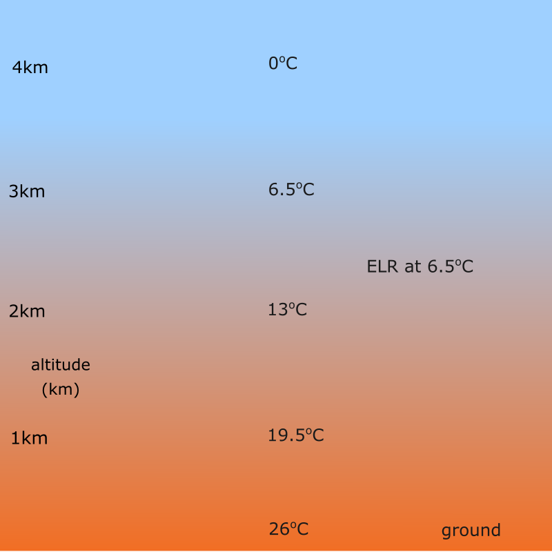
The decrease in temperature of the whole atmosphere with height. The average rate of decrease is 6.5oC/1000m. In other words, for every 1000m increase in height the temperature drops by 6.5oC.
However, this rate varies. It is higher during a hot day and low during a chilly cold day.

The environmental lapse rate is measured using radiosondes. These are instruments attached to helium filled balloons that ascend in the atmosphere collecting temperature, pressure and humidity.
Dry Adiabatic Lapse Rate
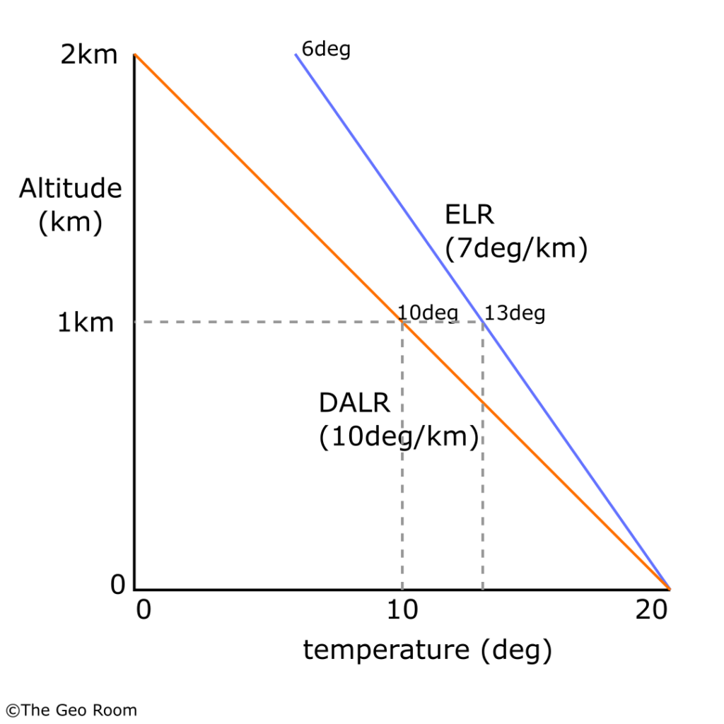
The decrease in temperature of air parcels with height. The rate of decrease is 9.8o/1000m or simply 10o/1000m.

The air is dry upon the fact that it has not reached saturation or has not condensed.
This DALR is constant.
Saturated(Wet) Adiabatic Lapse Rate
When an air parcel condenses it continues rising cooling at a slow rate due to latent heat released during condensation.
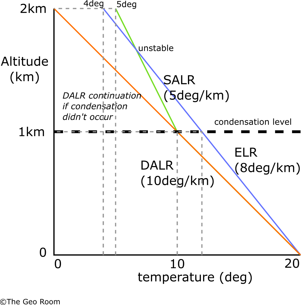
The SALR varies between 4 and 9 degrees; at 4deg for air with high moisture content to 9deg for dry air. The average rate of cooling is of 5o C/1000m
Now, let’s look at how these rates influence atmospheric conditions and weather.
Atmospheric Stability, Instability & Conditional Instability
Stability
Atmospheric stability occurs when the atmosphere (environmental lapse rate) cools more slowly than a rising air parcel (dry adiabatic lapse rate) which is cooling at a faster rate. For example, assuming that ELR is 7oC whilst the DALR is 10oC would mean that for every 1000m rise in height, the air parcel’s temperature is dropping faster and therefore cooler than the atmospheric air. The parcel of air will not rise as far because of its weight (cold air is dense) and therefore sinks back to lower layers producing calm weather, clear skies, and occasional drizzles.

Instability
This occurs when an air parcel (DALR) cools more slowly than the atmosphere (ELR) which is cooling faster. For example, assuming ELR is dropping at 12oC/1000m whilst the DALR is dropping at 10oC/1000m, would mean that the air parcel is warmer (cooling slowly) than the atmosphere.

The less dense warm air parcel continues to rise and eventually condenses producing unstable weather conditions. Cumulonimbus clouds may form resulting in heavy thunderstorms with frequent lightning. High wind speeds may result, and tornadoes may even form.
When condensation occurs, latent heat is released which reduces the air parcel’s cooling rate.
Conditional Instability
This occurs when the ELR is lower (warm) than the DALR but higher than the SALR. The air parcel cools faster than the atmosphere (stable conditions) but then cools slowly than the atmosphere after condensation.
The dense cold air must sink downwards but instead continues to rise given a constant uplift mechanism. The air parcel eventually condenses releasing latent heat which is used to warm the air parcel and cool it slowly at the SALR.
This latent heat offsets the cooling of the air parcel and the ELR now overtakes the air parcel in terms of cooling. The parcel is unstable because it has risen to condensation in the first place instead of sinking.

The weather associated with conditional instability is usually fine in areas below condensation level.
