Weather fronts are boundaries separating air masses of different characteristics(cold and warm).The word generally comes from the literal word of “battle fronts” in wars where armies would collide with each other.
Warm Front
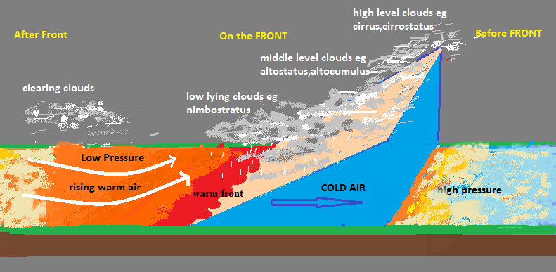
When warm air moves in a region formerly occupied by cold air it is called a warm front. On weather maps it is usually denoted by red triangles.When warm air catches cold air it rises on top of the cold air mass because of its lightness.
The warm air mass sort of squeeze down the cold air creating a low angled slope. Eventually the warm air mass cools and expands creating widespread clouds with light to moderate rainfall.
Usually rain intensity and cloud type depends on the stability of the warm air.If its stable moderate clouds such as altostratus or nimbosrtatus may form with continuous rainfall,but if its unstable cumulonimbus clouds with heavy rain may form.

Before the Front
- High presure conditions with steadily rising temperatures.
- High level clouds that are thin and wispy e.g cirrus.
- As we approach the warm front clouds start lowering, having medium level clouds such as altocumulus then low level nimbostratus clouds.
- Precipitation is usually light to moderate.
- Humidity gradually increases.
Prior to the front, visibility may be poor or good.
At the Front:
- Low pressure with high temperatures.
- Low level clouds dominate such as nimbostratus.
- Precipitation styles may change, experiencing some moderate rain with some sudden heavy downpours.
- Cumulonimbus clouds may form given that the warm air is unstable.
- Wind speeds are high due to the steepness of the pressure gradient on a low pressure.
- Visibility is often very poor due to the low lying clouds.
- Humidity is high.
After Front
- Pressure steadily rise and therefore temperatures also gradually decrease.
- After passing of front any snow or ice that might be on the ground may start to thaw(melt), this may contribute to floods.
- Clouds start clearing with some drizzles thus visibility starts to improve.
- Humidity gradually decreases.
Cold Front
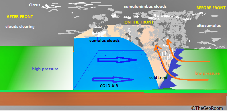
When cold air moves in an area fomerly occupied by warm air it is called a cold front.On a cold front a fast moving cold air “rams” with and undercuts warm air forcing it to rise.This mechanism is more unstable therefore cumulonimbus clouds with copius rainfall are most likely to develop.
 Cold Front
Before Front
- Pressure is low but steadily rise as we approach the front.
- Consequently temperature is high and slowly decrease as we approach the front.
- High to middle level clouds such as cumulus dominate with light to moderate rainfalls.
- Humidity is generally low.
On the Front
- Pressure suddenly increases and consequently temperature falls.
- Towering cumulonimbus clouds with heavy rainfalls and thunder dominate.
- Winds are gusty.
- Humidity falls.
After Front
- Pressure steadily falls away from the front.
- Temperature gradually rise away from the front.
- Clouds start dissipating with some occasional cirrus or cumulus clouds.
- Some showers may fall then clears.
- Humidity is low.
Occluded Front
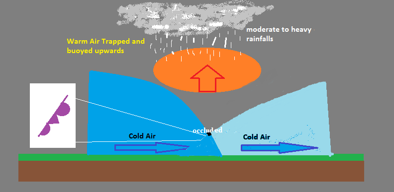
On weather maps this front is denoted by purple semi-circles and triangles. Forms when a warm airmass gets trapped between two cold air masses. The warm air is “occluded” (hidden) from the surface and rises as the cool air masses push and meet in the middle. The weather associated with occluded fronts often varies. An occlusion can be thought of as having the characteristics of both warm and cold fronts. They can be responsible for very heavy rains or snow events

Stationary Front
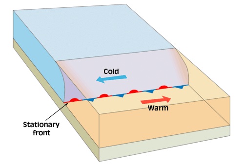
Denoted by mixed red circles and blue triangles. A stationary front occurs when two air masses move in opposite directions on either side i.e past each other
 Parallel Stationary
or when two air masses collide with each other but none has the potential to lift the other, thus the front is just motionless. The weather formed by the latter varies and may prevail for days.
 Stationary front resulting from collision of air masses with the same density