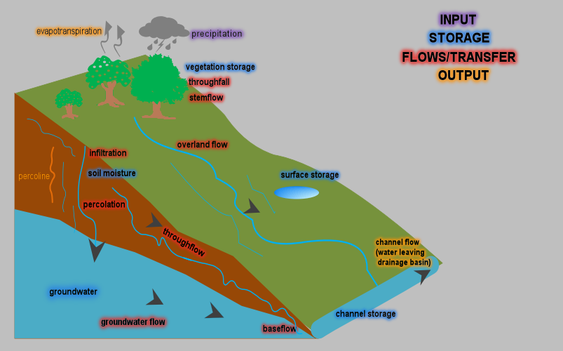
The Hydrological Cycle/Water Cycle is the continous circluation of water as liquid, gas or solid in the atmosphere and on earth. The hydrological cycle can be analyzed on a global scale or on a local (catchment) scale. The latter provide good estimates of hydrological processes. Estimates show that there is 1.6 billion km3of water on the globe.
The majority(97%) of water is found in oceans/seas. The remaining(3%) is distrubuted between lakes, rivers, glaciers, groundwater, atmosphere and marsh. On the global hydrological cycle evaporation rate is greater than precipitation, while on land the latter is greater than the former.
The difference in precipitation and evaporation constitutes to runoff. The global water cycle is rather misleading as the availability of water varies from place to place around the globe.
The drainage basin/catchment hydrological cycle provide good estimations of hydrological processes as the studies are done on a local scale rather than on a wider scale (global).
Drainage Basin Hydrological Cycle
A drainage basin/Catchment area is an area drained by a river and its tributaries. The Drainage Basin is an open system where there is the interaction between inputs, processes, stores and outputs.

Inputs
All forms of precipitation entering a drainage basin. They include rainfall, snow, sleet, hail. Other less significant forms of precipitation include dew, hoar and rime which occur on the surface.
Processes
These are flows and transfers of water within a drainage basin.
Through Fall
Precipitation that falls directly to the surface through gaps in the forest. Throughfall can be indirect with water dripping from branches or leaves to the ground.
Stemflow:
Water trickling down the stems of plants or trunks of trees.
Infiltration:
The initial sinking of water into the soil. Infiltration rate is how fast water sinks into the soil. It is measured in mm/hr. The maximum rate at which water infiltrates or is absorbed by the soil is termed Infiltration Capacity (also measured in mm/hr).
Various factors affect infiltration and includes:
Type of soil:
Sandy soils with more pore spaces have high infiltration rate than compact, cohesive clays.
Permability:
Hard surfaces especially in deserts makes infiltration less pronounced.
Rainfall Intensity and Duration:
Heavy short lived rainfalls does not favour infiltration whereas gradual, prolonged rainfall have abudant time to infitrate.
Vegetation:
Vegetation can favour or hinder infiltration. Vegetation can trap water from reaching the ground or can actually absorb water thus encouraging infiltration.
Raindrop Size:
Small water droplets infiltrate more than large droplets.
Soil Moisture (Antecedent)
Dry soils are thirsty and needs more water thus favours infiltration than already saturated soils which only encourage runoff.
Percolation
Percolation is the continous seepage of water underground through cracks, percolines and soil/rock spaces until the water fills all pore spaces within soil or rock forming a zone of permanent saturation.
Throughflow:
Near the surface(subsoil), water flows downhill through cracks, percolines or natural pipes untill it reaches a river. Throughflow occurs mostly in the unsaturated zone where impermable rocks hinders further percolation.
Baseflow
can be defined as the slow seepage of water from groundwater sources to the bed of a river which is the main contibutor of river flow during water deficits.
Stores
Water can be stored by:
Stored by plant leaves or roots
Groundwater storage
Natural reservoirs (lakes or puddles)
Artificial reservoirs, eg dams
Channel storages
Soil moisture
Outputs
This is water leaving the drainage basin.
Evaporation: Water is evaporated from different Storages within the drainage basin. Plants transpire water and the combination between the two is evapotranspiration.Water can exit the drainage basin as river flow.
