Limestone forms a wide variety of landforms (features) called Karst Landscape or Topography. Some range from small scale landforms to large scale landforms that can be several kilometres in length and height.
Most karst scenery is found in tropical regions where there’s a substantial supply of water and vegetation for humic acids e.g South East China, Carribean etc
Surface Karst landforms
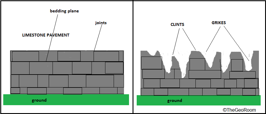
Limestone Pavements
Limestone pavements are small or extensive oucrops of limestone.You can imagine limestone pavements as the general pavement that you walk on.
Grikes and Clints
Owing to cracks or joints along the limestone pavement,grikes may form due to active eating (solution) along the cracks by acidulated water.
The hollow grooves(grikes) are separated by ridges called clints. Grikes can be very large across (several kilometres) a limestone terrain giving a criss cross pattern, these are known as Corridor Karsts or labyrinths

Dolines/ Sinkholes/ Swallow Holes / Ponor
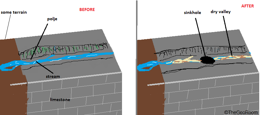
Dolines are roof holes or depressions in limestone formed when acid water or streams gradually wear down a small fracture on top of the limestone which eventually lead to that particular area collapsing.
Dolines may give way to sinking of streams down the limestone. That is why the name “sinkholes” is used. Sinkholes may vary in size from several metres to kilometres.

Uvala
An uvala is a huge depression spanning several kilometres formed from the coalescence of several dolines and sinkholes.
Polje
A polje is a near steep sided valley with a flat floor. Water along poljes does not drain fast enough thus during times of high river discharge floods can occur. Some poljes may be a result of tectonic activities and are very large.

Dry Valleys
These are traces of a prior river flow.When streams originating elsewhere enters a limestone area the stream may infiltrate or sink through a swallow hole and dissapears from the surface leaving a trace of dry channels. The stream now flows downwards as an underground river. When the stream reemerge on the ground from the limestone underground it is called a resurgence

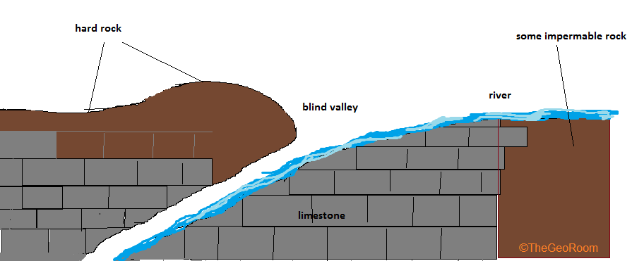
Blind Valley
Blind valleys are valleys closed at one end by a rock wall at the base of which is a sink where a stream vanishes underground. Blind valleys may be due to lowering of a river bed by solution around a sinkhole.

Gorge
Gorges form when rivers erode vertically rather than laterally. Due to joints on limestone and or its softness, rivers flowing in a limestone terrain gradually erode downwards along the joints forming narrow, steep-sided gorges.
Underground Karst Landscape
Underground Cave
Caves form when rivers and rain gradually hollow the inside of limestone rocks creating passages within the limestone. Acid water may eat through wall joints eventually collapsing it and creating the Cave entrance.
Examples in Zimbabwe include the Chinhoyi Caves. Caves lying above the water table are called vadose whereas caves lying below the water table are called Phreatic.
Speleothems
These are deposits of calcite inside the cave. When dissolved calcite drips from cave roofs it may dry out, another drip comes out and dry on top of the former eventually leading to an accumulation of dried out calcite that resemble a carrot hanging from the cave ceiling called a stalactite.
Some calcite may drop down and accumulate on the cave floor forming carrots that point upwards called stalagmites.
Stalactite and stalagmites may eventually join together to form a pillar. The rate of drying depends on the atmosphere inside the limestone cave.
Tip
You can easily remember: Ceiling (C) – stalactite
Ground (G) stalagmite
Flowstone
This is calcite that flows along cave walls and dry out.
Tropical Karst
Tropical Karst include Tower Karsts amnd Cockpits and mainly occurs in tropical regions such as South China due to high rainfalls, abudant soil carbon dioxide and humic acids from decaying matter.
Conical hills and Cockpits
These are semi-circular hills separated by star like depressions known as cockpits. These hills form when streams and rain erode along weak sections in a limestone terrain.
 Conical karst, Yunnan Province, ChinaFlickr
Tower Karst
These are tall topographical features standing at 200m or more. There are formed when rain water or streams gradually wears down vertical joints along limestone resulting in steep sided towers separated by rivers or sediment plains. These are the bornhardt version of limestone.
 Tower Karst img sourceResearchgate